- Overview
- Trip Outline
- Pricing
- Trip Includes
- Trip Excludes
- Gallery
- Reviews
- FAQ
Route:

Technical Characteristics
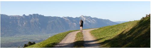
Tour Profile: Medium. The route consists exclusively of the existing network of paths and trials. Ascents and descents to a maximum of 2,000 meters. Good hiking shoes are required as many of the sections, especially Triesen-Triesenberg, Triesenberg-Vaduz, Planken-Nendeln and Ruggell-Schellenberg contain steep sections.
Total distance: 75 km
Travel Season: Departures daily from May 1 to October 1, 2023
Accommodation:
Comfortable 3* hotels
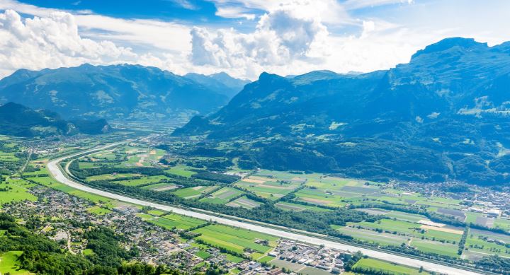
The Liechtenstein Trail connects all of Liechtenstein’s municipalities, and extends an invitation of the whole country, as well to guests from abroad, to head out on an exciting journey through Liechtenstein. Along this trail, you can not only discover and celebrate the history of the country but also experience the Principality of yesterday, today and tomorrow. 147 specially selected historical sights and events, are all connected through the Liechtenstein, which is around 75 kilometers long. The trial follows the existing network of paths and trails through all 11 municipalities and offers spectacular views, fine food and secluded spots.
Itineraries
Day 1
Individual arrival in Balzers
Individual arrival and check in at your hotel.
Day 2
Balzers - Triesenberg.14 km + 572 m - 184 m
Gutenberg Castle, which towers around 70 meters above Balzers is visible from afar. After we have passed the medieval castle, the Liechtenstein-Weg leads us through the municipality of Balzers and then over the Alte Romerstrasse to Triesen. In the middle of the old part of the village we then reach the area of the former cotton weaving mill Jenny, Sporry & Cie. From the Gasometer cultural center in Triesen, the path climbs steadily to the St. Mamerten chapel. There we can linger comfortably and enjoy the peace and quiet and the wonderful view. This is followed by the steep ascent to the Walser village of Triesenberg. The village centre is around 900 meters above sea level. It emerged from a Walser settlement in the 19th century and has honoured its history and tradition over the years. The Triesenberg Walser Museum impressively shows this history of the Walser immigrants.

Day 3
Triesenberg - Vaduz 10 km + 264 m - 692 m
From the center of Triesenberg the path leads us to an impressive boulder. Then we get to the Prufatscheng homestead, which is a listed building, via a steadily ascending road. From here we enjoy a fantastic view of the Rhine Valley. Then it goes steeply downhill on a hiking trail into the forest to the ruins of Schalun Castle. The ruins of Schalun Castle are located on a rock terrace about 400 meters above the centre of Vaduz. As soon as the path becomes flatter, we can already enjoy a wonderful view of Vaduz Castle from the Quadretschaweg. From Vaduz Castle, the narrow and steep castle path meanders down into the small town of Liechtenstein’s capital, Vaduz. In the traffic free Stadtle, the Liechtenstein-Weg leads us along the museum mile with the art museum and the Hilti Art Foundation, the postal museum, the treasury and the state museum into the government district of Vaduz. There it is worth taking a look at the state parliament building designed by the German architect Hansjorg Goritz and the government building next to it. We continue on lesser known paths from the St. Florin Cathedral to the Old Rhine Bridge, then along the Rhine and past the football stadium back to the center of Vaduz.
Day 4
Vaduz – Nendeln 17 km + 571 m - 576 m
On the Liechtenstein-Weg we come into Vaduz steadily uphill along the vineyard of the Hofkellerei of the Prince of Liechtenstein through Alt-Vaduz to the Red House. From there we enjoy a wonderful view of Vaduz Castle. It then continues on a forest path to the University of Liechtenstein. The path then becomes flatter and leads us to a debris flow (also called Rufe) and then to the ruins of a Roman fort up to the village center of Schaan. In Schaan the route climbs up to the St. Elisabeth monastery before a short flat section to the Gamanderhaus follows. From the Gamanderhaus there are around 300 meters of altitude to conquer on forest paths to Planken. From Liechtenstein’s smallest community, hikers have a wonderful view of the valley and the Three Sisters mountain range above Planken. Now follows the very deep descent on a mountain hiking trail to Nendeln. When we arrive in Nendeln, the path leads us past the remains of a Roman estate to the center of Nendeln.
Day 5
Nendeln - Ruggell 15 km + 269 m - 289 m
Passing the Nendeln train station, we get to the Eschen/Mauren sports park and from there to the center of Eschen. The path then climbs slightly via Gudigen to Aspen and from there down again towards the village center. Now the path goes up again and we pass the Rofenberg Chapel. At Krest we enjoy the beautiful view and follow part of the historical high path. Finally it goes down to the church hill in Bendern and from there to the post office in Bendern. The church hill has probably been inhabited for 4,000 years, and a church should have stood there in the 6th century. The route then leads us from Bendern along the Rhine to the Grossabunt leisure facility in Gamprin. At the Grossabunt bathing lake, you can linger and eat. Then it goes on to the village center of Gamprin. We then hike along a part through the Kratzera forest to the center of the village of Ruggell. Ruggell is the northernmost municipality in Liechtenstein.

Day 6
Ruggell - Schaanwald 19 km + 507 m - 479 m
In Ruggell we first get to Kuefer-Martis-Huus. The listed building from the 18th century is the community’s cultural center. You then continue over the Binnendamm to the Riggeller Riet, a nature reserve of around 90 hectares in northern Liechtenstein. Fauna and flora offer nature lovers a wonderful experience of nature. After the flat Riet, the steep ascent to Schellenberg follows, where we first pass the ruins of the Lower Castle. Past the monastery, the path finally leads us to the village center of Schellenberg. In Schellenberg we pass the sports field and then move to Hinterschellenberg near the Austrian border. On nice days, the panoramic view extends to Lake Constance. A partly narrow hiking path then leads us through the forest along the Gantenstein to the Upper Schellenberg. Here is a good place to rest. Now it goes over a former smuggler path down to the village center of Mauren to the post office. We can see the parish church of St. Peter and Paul in the center of the village of Mauren from far away. From the village center of Mauren, the path first climbs gently to the Fallsgass and then down to the silk tree path. The name comes from the fact that mulberry trees were previously used in silk production. Then we get to the bird paradise Birka via flat reed roads, where we can take a break. The memorial plaque here, which reminds of the water level from the Rhine flood in 1927, is very impressive. Then we pass the Maurer Riet and come to the Schaanwald Funkenplatz to the customs office on the Liechtenstein/Austria border.
Prices
Included:
- 6 days / 5 nights’ accommodation including breakfast
- Welcome drink and introduction
- Luggage transport service (maximum 1 piece of luggage per person)
- Daily packed lunch
- Adventure Pass Liechtenstein (including free use of public transport)
- Map of Liechtenstein / Free download "LIstory” App)
Not Included:
- Any visitors taxes, payable locally
- Personal expenses
No Details Found
Related Trips
-
 8 Day(s) 7 Night(s)


There are no reviews yet.