- Overview
- Trip Outline
- Pricing
- Trip Includes
- Trip Excludes
- Gallery
- Reviews
- FAQ
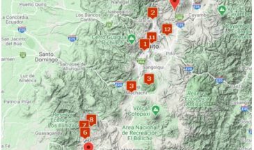
Route:
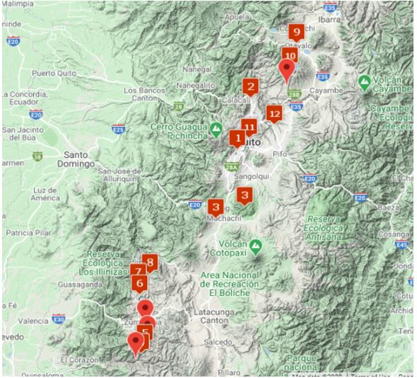
Technical Characteristics:
Route Profile: Medium. Daily walks up to 6 hours per day, at high altitude. Previous hiking experience and physical conditioning would be of benefit.
Travel Season: Any date on request from January 2 to December 31, 2023
Accommodation:
3* hotels, lodges and tents
The Ecuadorian Andes region, with its numerous volcanoes at different altitudes, gorgeous nature and exotic indigenous villages and cultures, makes trekking here the experience of a lifetime. On this twelve day itinerary we offer you an excellent acclimatization program, including a trekking program in an absolutely beautiful, authentic and remote area, which is rarely visited by other tourists or mountaineers. After the trek, the itinerary goes north to the region of Otavalo, to ascend up to a lovely summit called Fuya-Fuya, followed by a visit to the Otavalo market and the archeological ruins of Chocasqui.
Itineraries
Day 1
Arrival in Quito
Reception at the airport and transfer to hotel.
Day 2
City Tour in Quito
Half day private city tour in the historical part of Quito, including La Basilica Church, La Compañia Church and El Panecillo Hill. We leave the hotel, by private transportation, and will see the transformation from the new part of the city to the absolutely beautiful historical and colonial part of Quito. We will have time to see all the interesting churches, plazas etc. But also simply enjoy the local atmosphere, the many shops and sellers. After these interesting sights, we continue to “El Panecillo”, the hill in the centre of Quito with a view of the city and the historical centre. Also from here, on clear days, we may observe several of the snow-capped volcanoes surrounding Quito.

Day 3
Climb: Pasochoa Volcano (4164 m) 5 hours + 516 m
Pick up at hotel in Quito and transfer (two hours) to the head of trail, located at an altitude of 3848 m. From this point a very well-marked trail will lead the way by farm land up to the paramo area. Here the trail heads southwards ascending progressively until the base of the crater. The last section is the steepest, following a mountain trail up to the crater rim. The last meters to the summit are done by the edge of the crater with nice views down to the valley of Machachi, also known as the “Volcanoes Avenue” and the highlands to the west. On clear days there is a perfect view to the Cotopaxi, Sincholagua, Rumiñahui and Artisana volcanoes. The descent is following back on the same trail. Back at the starting point the group will be transferred (two hours) to the outskirts of the Machachi (2930 m).
Day 4
Trekking: Los Pinos campsite (3300 m) 3 hours + 315 m
An early transfer (four hours) to the town of Angamarca (2985 m), located on the western flank of the Andes. The first part of the road is very good, leaving it after two and a half hours for a dirt road that
makes the last bit of the trip a bit slow. There will be a couple of stops
at viewpoints, as the landscape is very nice and different from the main valley, where Quito is located. Angamarca is a remote village with a traditional way of life, which gives a good insight of the local lifestyle.
The trek starts from the town, after having lunch. The day’s hike is
about three hours and follows a local trail to meet a dirt road which
leads to the first camp: Los Pinos (3300 m).

Day 5
Trekking: Pigua Campsite (4073 m) 6 – 7 hours + 900 m - 127 m
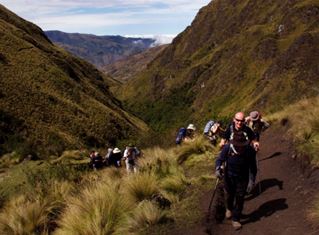
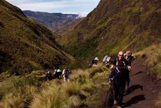
After breakfast and having taken down the camp, the ascent will follow the Yayachanchi’s valley up a river that carries the same name. The hike starts on a dirt road and after 30 minutes it takes a local trail. The ascent is constant and very enjoyable; passing corn and bean fields on the way. After a relative steep climb, the first houses of the Yayachachi town (3900 m) will appear. This isolated settlement, was until recently only accessible by foot or horse, but a recently opened dirt road has eased access and improved the life of the local people. A short break for a snack and then keep on by the same valley, leaving the settlement, and aiming at a well-marked ridge which, after gaining altitude, traverses towards the east, reaching the Pigua mountain pass (4200 m). From the pass an easy descent to one of the most beautiful valleys on the trek, crossing a river, and heading to “La Chorrera de Pigua” (Tigua’s waterfall), where the camp (4073 m) will be set up.
Day 6
Trekking: Quilotoa Crater Lake (3900 m) 6 hours + 393 m - 766 m
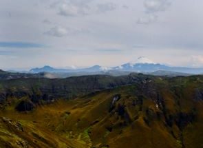
Leaving Pigua’s campsite, taking an almost non-existent trail up the mountain side heading east, will lead us to the highest point on the trek: Zumbagua mountain pass (4466 m). This pass has some of the best views to the high volcanoes, when clear, it is possible to see Cotopaxi, Ilinizas, Chimborazo, Los Altares and the active Tunguragua with its smoke column emerging from the crater. From the pass, a green valley opens downwards, tying in a lower valley that continues to an Indigenous settlement. After the settlement and descending a narrow gorge, the local’s transports will take the group (30-45 minutes) to the town of Zumbagua and from there on to Quilotoa’s Crater Lake (3900 m). Quilotoa is a known tourist attraction in Ecuador, due to its great location and the perfect round shape of the crater and the deep green colour of the lake inside the crater. The place is very relaxed and perfect to enjoy a cold beer watching the sunset, with the Ilinizas in the background.
Day 7
Trekking: Chugchilan town (3198 m) 5 hours + 203 m - 1025 m
At about 8 a.m. we will start our trek by the western trail, hiking around about a third of the crater by a spectacular trail by the upper edge of the rim. With clear skies the view is incredible towards the distant Cotopaxi and Illinizas volcanoes, the lake at the bottom of the crater, the western valley and Guayama and its town. From the rim, we will descend into the Guayama Valley and follow a series of trails and dirt roads until we reach the Rio Toachi gorge. This last section is quite steep following an old trail to the river crossing, where a short hike will lead us to the town of Chugchilan and our local lodge.
Day 8
Trekking: Insilivi town (3000 m) 5 hours + 150 m - 200 m
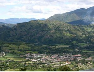
From Chugchilan the landscape becomes greener and colorful. There is plenty of small local production of the most basic harvest as potatoes, corn, beans, etc. The lifestyle is still very traditional and it is mainly inhabited by peasants and descendants from Indigenous groups. We will walk by a changing landscape with valleys and gorges decorated with the Toachi River, until our next stop at Insilivi town, where we will stay at another lovely lodge and enjoy a pleasant afternoon.
Day 9
Town of Otavalo (2600 m)
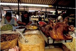
After breakfast, the tour continues to the town of Otavalo. It will take approximately four hours to reach the town. The drive is fascinating, as it travels through the relatively dry areas caused by the “rain shadow” of the volcanoes, and it is easy to observe the sediments suggesting the formation of this part of the Andes. Crossing the Equatorial line and soon we pass into the lush Otavalo region, where the Otavalo Indians have managed to continue their proud traditions. This valley is very beautiful, surrounded by smaller volcanoes and lakes. There will be a stop to visit the Equatorial monument and learn about this interesting place. Upon arrival in Otavalo, there will be time to visit the food market, a very interesting spot and seldom visited by tourists. In the afternoon, the guide will do a briefing for the next day’s activities.

Day 10
Climb: Fuya-Fuya Volcano (4100 m) 5 hours + 300 m - 300 m
Early morning departure, taking the Pan-American Highway back towards Quito. A few kilometers from Otavalo, a dirt road (one hour) will lead the way up to the Mojanda reserve; an inactive volcano with a turquoise lake called Caricocha. Mojanda has two extinct volcanoes: Fuya-Fuya and Cerro Negro, very close to each other. The main objective in this itinerary is Fuya-Fuya (4100 m). The trek starts from the lake’s shores (3800 m) and follows a well-defined trail through grassland and shrub lands (Paramo) up to the summit. This is a very nice trek, with a gentle ascent and incredible views down to the exploded caldera. Once back at the parking place, the vehicle will take the team back to Otavalo.

Day 11
Otavalo’s Market and Cochasqui’s Ruins
Free morning at Otavalo’s famous indigenous market. After lunch transfer (one and a half hours) to the archaeological ruins of Cochasqui, where we will have the opportunity to visit some of the best-preserved pyramids and listen to the local history. From Cochasqui we have about two hours to our hotel in Quito.
Day 12
Departure
Time to leave the volcanoes of Ecuador! Pick up at the hotel and transfer out to Quito’s Airport (one to two hours). End of services.
Prices
Included:
- Local mountain guide during the entire program
- Assistant mountain guide during the mountain itinerary in ratio 1:5
- City guide for Quito’s city tour
- Private transportation throughout the entire program
- 3 nights in shared double rooms in hotels in the city of Quito
- 1 nights in shared double rooms in the town of Machachi
- 1 night in shared double room in basic lodge in the town of Quilotoa
- 1 night in shared double room in lodge in the town of Chugchilan
- 1 night in shared double room in lodge in the town of Insilivi
- 2 nights in shared double room in hotel in the town of Otavalo
- 2 nights in shared double tents in campsites
- Meals as specified in the itinerary ( 11 breakfasts, 7 lunches and 6 dinners)
- Entry fee to the National parks and natural reserves
- Entry fees to museums and sights mentioned in the program
- Quality mountain tents – 2 people per tent during the trek
- Group common campsite equipment
- Porters and mule/horses for group campsite equipment and personal equipment
- Cook during the trek
Not Included:
- Domestic and international flights
- Meals not mentioned in the program
- Alcoholic and soft drinks
- Personal expenses
- Personal camping gear
- Tips
- Everything not mentioned in the “Included” list
No Details Found






There are no reviews yet.